Discover Colombia
Map of Colombia: regions, departments, cities and distances
The map of Colombia explained for travellers: the six natural regions, the 32 departments and their capitals, the Andes and distances between the main cities.
In this guide
Looking at a map of Colombia before you go is the quickest way to understand how to plan your trip. The country is big, roughly twice the size of France, and the Andes run through it, splitting it into valleys, high plateaus and two coastlines. The result is that cities that look close on the map are separated by 10-20 hours by bus on mountain roads, and that the climate changes more with altitude than with the season. Here you’ll find the interactive map, the regions, the departments and their capitals, and the distances that matter for an itinerary.
Interactive map of Colombia
Where is Colombia?
Colombia sits in the north-western corner of South America, the only country on the continent facing two oceans: the Caribbean Sea to the north and the Pacific Ocean to the west. It borders Panama to the north-west, Venezuela and Brazil to the east, and Peru and Ecuador to the south. The equator crosses the south of the country, in the Amazon.
| Fact | Value |
|---|---|
| Area | about 1,141,000 km² (440,000 sq mi) |
| Population | over 50 million |
| Capital | Bogotá, at about 2,600 metres (8,500 ft) |
| Neighbouring countries | Panama, Venezuela, Brazil, Peru, Ecuador |
| Coastlines | Caribbean Sea and Pacific Ocean |
| Administrative division | 32 departments + the Capital District of Bogotá |
| Highest mountains | Sierra Nevada de Santa Marta, about 5,700 metres (18,700 ft) |
| Main river | Magdalena, over 1,500 km (930 mi) |
The physical map: the Andes and the six natural regions
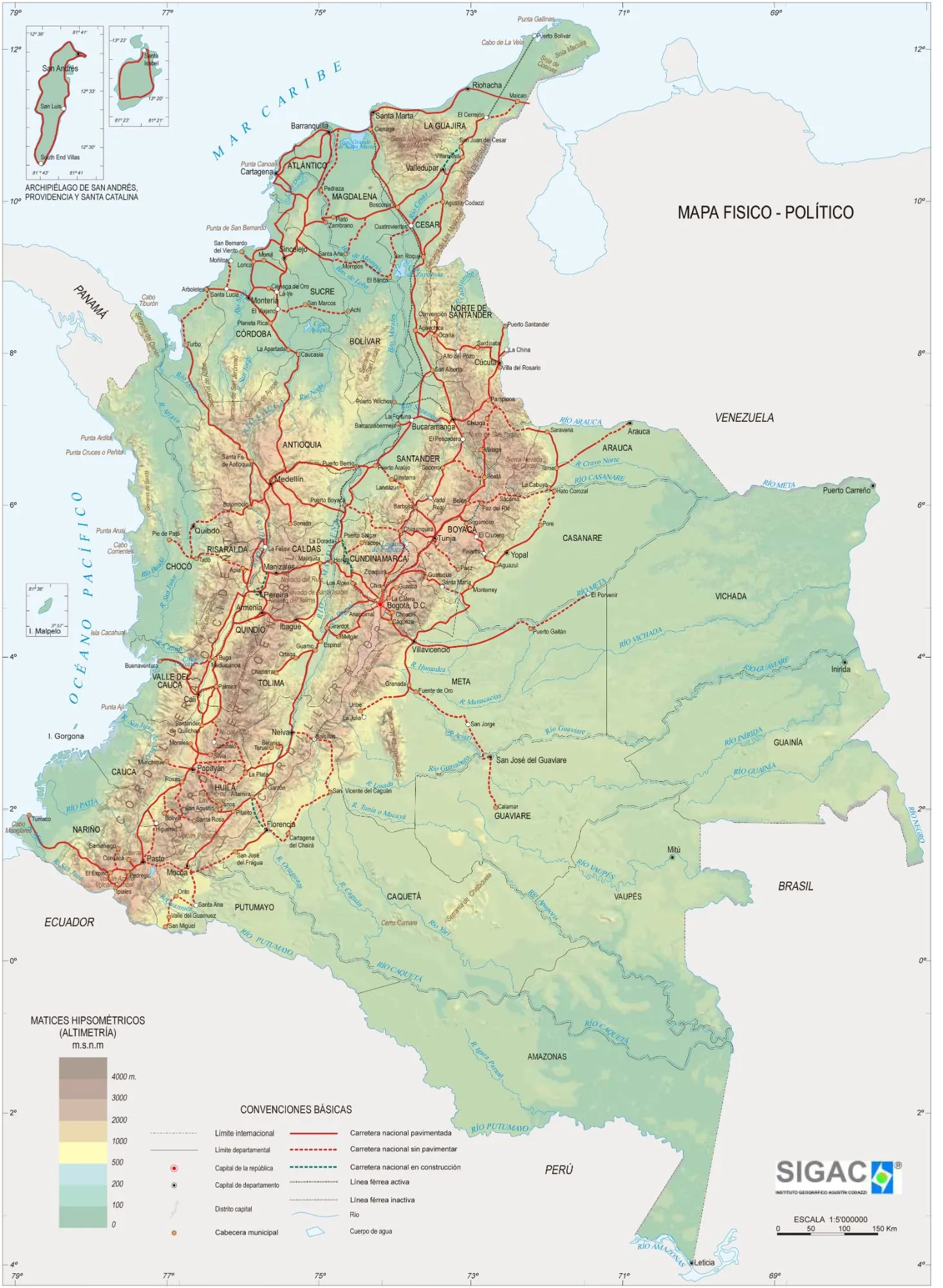
Physical and political map: Instituto Geográfico Agustín Codazzi (IGAC).
In the south, on the border with Ecuador, the Andes enter Colombia and split into three ranges running north like the fingers of a hand:
- the Cordillera Occidental (Western range), closest to the Pacific;
- the Cordillera Central (Central range), with the volcanoes and snow peaks of Los Nevados National Park above the Coffee Region;
- the Cordillera Oriental (Eastern range), the widest, with the high plateau of Bogotá and Boyacá.
Between the ranges flow the two main rivers, the Cauca and the Magdalena, which empty into the Caribbean. This geography gives the six natural regions Colombians divide their country into:
| Region | Where | What to expect | On this site |
|---|---|---|---|
| Caribbean | the north coast | hot all year, beaches, colonial cities | Caribbean coast |
| Andean | the three ranges and their valleys | big cities, cool to spring-like climate, coffee | Central Andes, Antioquia and the Coffee Region |
| Pacific | the west coast | rainforest, whales from July to October, few connections | — |
| Orinoquía | the eastern plains (Llanos) | savannah, cattle ranching, Caño Cristales | — |
| Amazon | the south-east | rainforest and rivers, reachable only by plane (Leticia) | — |
| Island | San Andrés and Providencia in the Caribbean, Gorgona and Malpelo in the Pacific | sea and coral reef | — |
The Sierra Nevada de Santa Marta, near the Caribbean coast, is a massif separate from the Andes: it’s the world’s highest coastal mountain range, with peaks around 5,700 metres (measurements vary by source) less than 50 km from the sea. At its foot lie Tayrona National Park and the trek to Ciudad Perdida.
Colombia’s 32 departments and their capitals
Colombia is divided into 32 departments, plus the Capital District of Bogotá, which isn’t part of any department. Each department has a capital, but many tourist destinations aren’t capitals, such as Villa de Leyva in Boyacá or Guatapé in Antioquia.
| Department | Capital | On this site |
|---|---|---|
| Amazonas | Leticia | — |
| Antioquia | Medellín | Medellín, Guatapé, Jardín, Jericó, Santa Fe de Antioquia |
| Arauca | Arauca | — |
| Atlántico | Barranquilla | — |
| Bolívar | Cartagena | Cartagena |
| Boyacá | Tunja | Villa de Leyva |
| Caldas | Manizales | — |
| Caquetá | Florencia | — |
| Casanare | Yopal | — |
| Cauca | Popayán | — |
| Cesar | Valledupar | — |
| Chocó | Quibdó | — |
| Córdoba | Montería | — |
| Cundinamarca | Bogotá | Zipaquirá |
| Guainía | Inírida | — |
| Guaviare | San José del Guaviare | — |
| Huila | Neiva | — |
| La Guajira | Riohacha | — |
| Magdalena | Santa Marta | Santa Marta, Tayrona, Minca, Taganga |
| Meta | Villavicencio | — |
| Nariño | Pasto | — |
| Norte de Santander | Cúcuta | — |
| Putumayo | Mocoa | — |
| Quindío | Armenia | Salento |
| Risaralda | Pereira | — |
| San Andrés, Providencia y Santa Catalina | San Andrés | — |
| Santander | Bucaramanga | — |
| Sucre | Sincelejo | — |
| Tolima | Ibagué | — |
| Valle del Cauca | Cali | — |
| Vaupés | Mitú | — |
| Vichada | Puerto Carreño | — |
Bogotá is the capital of Cundinamarca but, as the Capital District, has its own separate administration.
Distances between the main cities
On the map Colombia looks easy to cross by bus, but the roads climb through the Andes with bends, steep climbs and roadworks. That’s why between the big cities a domestic flight is almost always the right choice, while buses work well for short hops.
| Route | By bus | By plane |
|---|---|---|
| Bogotá – Medellín | 9-10 hours | about 1 hour |
| Medellín – Cartagena | 13-14 hours | about 1 hour 15 |
| Bogotá – Cartagena | 18-20 hours | about 1 hour 30 |
| Bogotá – Santa Marta | 16-18 hours | about 1 hour 30 |
| Cartagena – Santa Marta | 4-5 hours | — |
| Medellín – Salento | 6-8 hours | fly to Pereira or Armenia |
| Medellín – Guatapé | about 2 hours | — |
Airlines, prices and tips for each type of transport are in the guide to getting around Colombia.
FAQ
How big is Colombia?
Colombia covers about 1.14 million km² (440,000 sq mi), roughly twice the size of France. That’s why people fly between the main cities: Bogotá-Cartagena is about 1 hour 30 by plane versus 18-20 hours by bus.
How many departments does Colombia have?
Colombia has 32 departments plus the Capital District of Bogotá. The ones travellers visit most are Bolívar (Cartagena), Magdalena (Santa Marta and Tayrona), Antioquia (Medellín), Quindío (Salento) and Cundinamarca with Bogotá.
Which countries border Colombia?
Five countries: Panama to the north-west, Venezuela and Brazil to the east, and Peru and Ecuador to the south. It’s also the only country in South America with coastlines on both the Caribbean and the Pacific.
What are the regions of Colombia?
Colombians divide the country into six natural regions: Caribbean, Andean, Pacific, Orinoquía (the Llanos), Amazon and the island region, with San Andrés and Providencia.
More about Colombia
Discover Colombia
The flag of Colombia: colours, meaning and history
The flag of Colombia: why yellow fills half the flag, what the colours mean, where the tricolour comes from and when you'll see it flying everywhere.
Discover Colombia
Football in Colombia: league, clubs, stadiums and the national team
Football in Colombia: how the Liga BetPlay works, the big clubs and clásicos, how to buy match tickets and the story of the Colombian national team.